Click on any illustration with colored border to see it full size.
The only place you can cruise within the continental United States and enjoy Caribbean-like conditions is in the Florida Keys, especially the farthest of all the keys - the Dry Tortugas, best accessed from Key West, a distance of 70 nautical miles (80 land miles).
Note: To read about sailing to the Dry Tortugas from the west coast of Florida - Tampa Bay, Sarasota, Fort Meyers - go to Dry Tortugas from west coast.
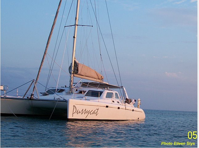
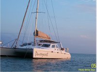
During Spring vacation 2007 four adults and four teen-aged boys embarked on such a cruise. The vessel chosen was a 45 foot catamaran because of its extensive and comfortable accommodations, particularly the large main cabin and cockpit. The captain and first mate each had thiry-five years sailing experience throughout the Caribbean and in the Mediterranean, as well as in U.S. waters. However this was their first experience cruising on a large catamaran. After reading many laudatory accounts of the fast sailing capabilities of catamarans, they had high expectations, but this vessel proved to be disappointing. As the story will reveal it had many problems. The very poor calibration of the navigation instruments would have proved daunting, even dangerous, to any charterers with less experience.
Charter yacht problems
 On Saturday morning, while the rest of the crew completed purchasing provisions, the captain and mate went through the briefing with the charter operator. This lasted about three hours as there is a lot of equipment on this 45' catamaran. We also discussed sailing routes and good places to anchor. Hurricane Wilma in 2005 had transformed many channels, these changes had not yet been inserted into the area charts. It was aleady after 14:00 when we pulled away from the dock, which is 5 miles east of Key West itself. The east wind was blowing 15-20 knots, with 5-6' swells. Immediately we noticed that the wind speed indicator was reading over 100% low (white caps indicated a wind speed of over 15 knots, the wind-speed indicator read only 6.5 mph). We practiced raising the very large fully battened main-sail with two reefs, and immediately ran into problems. It took us over an hour to figure out how to install the first reef, after giving up on the second reef. As a later inspection revealed, the operator had incorrectly installed the reef points, while reinstalling the main sail which had been damaged by a previous charterer. When we finally set off down-wind to head towards our first planned destination - Boca Grande, a small island about 20 miles west of Key West - I realized that the catamaran was not sailing as fast as I had expected, and with the lost time there was a danger that we would not arrive before sunset. Therefore I decided to pull into the anchorage just north of Key West town for the night.
This boat had a GPS connected to a computer with a 15" screen on which detailed charts are shown with the track of the boat traced on them as we sailed. Just as we were pulling away from Key West harbor under sail, the GPS transponder went out and we lost all position information. All attempts during the next hour to correct the situation were unsuccessful. I quickly plotted courses on the paper charts while we were sailing in approximately the correct direction. I was completely unaware of the fact that the instruments showing distance traveled and speed were in error by over 30%! They were reading low, so that when the instrument showed we had sailed 5 miles at a disappointing 5 mph, we had actually gone close to 7 miles. Nevertheless, by visual observations and taking bearings on visible objects, such as buoys and islands, I was able to navigate around an extensive shoal that was not on the charts (but about which we had been warned during the briefing) and we pulled into a pleasant anchorage to the west of the westernmost low-lying island of the Marquesas Keys, about half-way between Key West and our final destination - the Dry Tortugas.
We looked at the long beach about half a mile away and started to lower the dinghy. It is about 15 feet long, with a fiberglasss bottom and large 15HP engine, so it is very heavy. A derrick slides out from the main boom, and a sling is lowered by the main halyard over a pulley at its end. But it took nearly an hour to figure out all the controls and lower the boat into the water. Eileen took the boys towards the beach but it became too shallow for the big engine when they were still a few hundred feet away. The boys didn't want to wade ashore through the bottom grass. While Eileen was trying to start the engine again, the strong northbound current was carrying them further away from "Pussycat". Finally she got the engine started and they returned, for swimming from the boat.
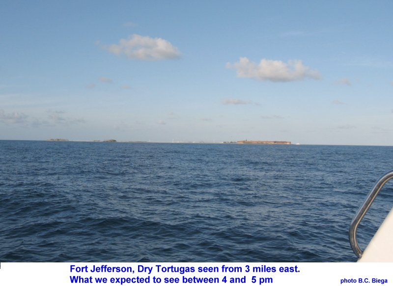
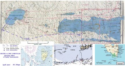
 The next morning we still had a struggle to get the dinghy back onto its place on the stern platform. The next few days we got better and better, but it was always a job that required at least three people and over quarter of an hour. I plotted a course for Fort Jefferson in the Dry Tortugas. We were sailing downwind, but it appeared that the fastest we could go under sail was 4.5 mph (the instruments don't register in knots!), I was still unaware of the over 30% error. After a couple of hours I decided we could not cover the 36 miles fast enough to anchor before sunset, so we started one engine and motorsailed the rest of the way at an apparent 6 m.p.h. At our briefing we had been told to expect a northbound current of up to 2 knots. In the third hour we were searching for the beacon on the dangerous Half Moon and Rebecca Shoals, but never saw them. However after several hours the depth-sounder started showing much greater depth than on the chart. It appeared that for some reason we were being carried southward of our planned course to where the chart showed deeper water. I made a 15º northward correction to our course. We expected to see the fort on the horizon ahead of us shortly after 16:00, but nothing appeared. Also we had not seen any other boats for some time. Suddenly Eileen spotted a white mark on the horizon to the north of us, a sail or a tower? We changed course and headed straight for it. It soon resolved into the lighthouse on Loggerhead Key at the west edge of the Dry Tortugas. We were several miles west of where we expected to be because we had been sailing 30% faster than the instruments showed and, because of an unexpected current, several miles south, see the chart.
As we approached our destination, new problems arose. The heads (toilets) started overflowing, and our fresh water faucets ran dry. Problems we had never encountered in our previous 12 charters. We always ran a tight ship - no fresh water showers for anyone, nothing deposited in toilet bowls, not even toilet paper. Apparently the fresh water tanks had not been filled and the holding tanks had not been pumped out.
Fort Jefferson National Park
Shortly after we turned, we spotted a yellow buoy, as we approached it turned out to be buoy "C" at the entrance to the South-west channel, the easiest channel for entering the Dry Tortugas. We had clear sailing towards red marker "4", east of the Loggerhead Key, then following the well marked channel into the Garden Key anchorage. However, the wind had shifted to the north-east directly on our nose, even with both engines at full revs the sun was setting when we reached marker #4. I was amazed to see Loggerhead Key almost completely denuded of the trees that covered it at my last visit 10 years earlier. We called any boat in the anchorage. An immediate response guided us into a secure position for anchoring. We spent the whole next day relaxing, taking the tour of the fort, swimming and snorkeling.
No water is available in the Dry Tortugas, so we were in a difficult situation. In the morning we contacted the government vessel that was anchored at the dock, but without result. However others overheard our call. Donations from the Park Service, the Key West ferry and another charter yacht, provided us with enough water for drinking and essential cooking to carry us through the rest of the week (together with four gallons of bottled water remaining in our own supply).
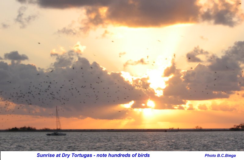
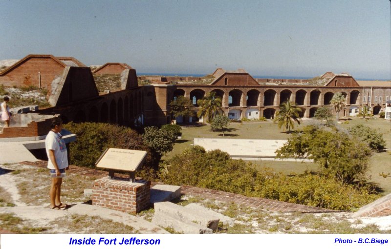
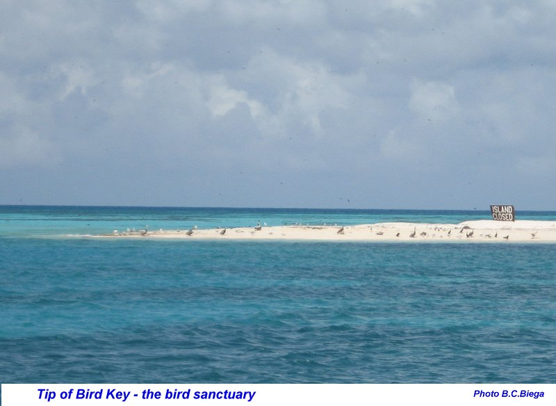
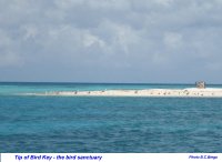
 Fort Jefferson, the largest brick fort in the United States, is the principal tourist attraction. There are sandy beaches and good snorkeling all around the fort, with some coral, but lots of colorful fish. The sandy Bush and Long Keys, east of the fort, are a bird sanctuary closed to visitors during the nesting season of the terns, from February through September. Thousands of birds maintain a loud chatter day and night. The abundance of fish attract many pelicans that perch on the pilings of the ruins of the old navy docks. The views of the vividly colored water, the spectacular sunrises and sunsets, add an additional reason to visit this unique, isolated island. The only approach is by boat or by the seaplanes that land and take off reguarly among the anchored boats. There are very limited camping facilities.
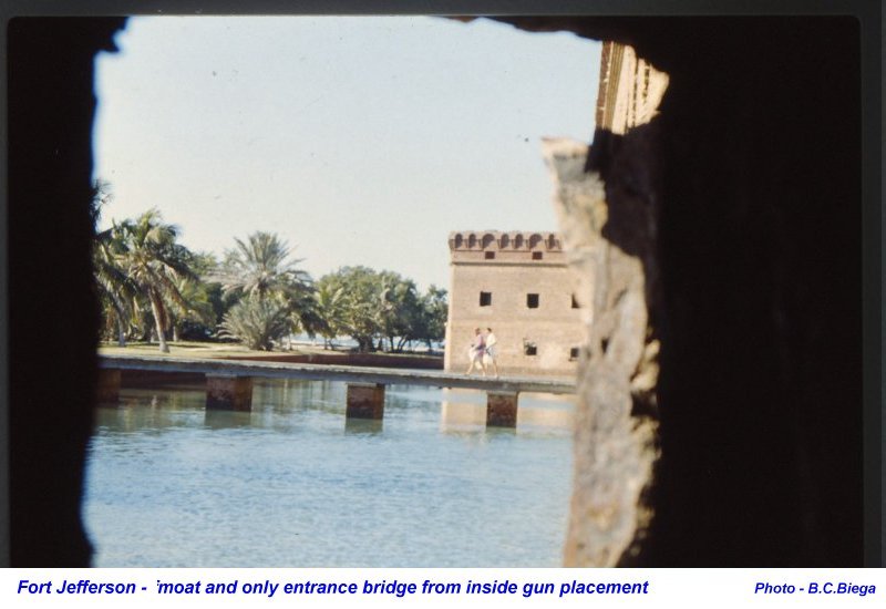
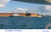 The construction of the fort started in 1846, but was never fully completed. During and after the Civil War it served to house prisoners, both Confederate Army and deserters from the Union Army. The most famous prisoner was Dr. Samuel Mudd, the physician who innocently treated the leg of President Lincoln's assasin. For this he was convicted of treason and imprisoned at Fort Jefferson. He was pardoned in 1869 for his heroic efforts treating prisoners and guards who contracted yellow-fever.
| More Fort Jefferson pictures |
 |
 |
 |
Other Keys - Woman Key, Sand Key
 Steve, another yacht charterer, hearing about our problems, loaned us his personal pocket GPS for hikers. This was a great help in the return voyage, enabling us to verify dead-reckoning positions and check actual distance traveled and speed at all times. I also consulted with the ferry skipper, who checked his tide tables and verified that the tidal current in the Rebecca Shoal channel was exceptionally strong at this time of spring full moon. It was running southward at about 2 knots in the afternoon. In the morning it was running about 1 knot northward. Secure with this knowledge, we pulled up anchor at sunrise Wednesday and left the anchorage feeling our way through the shoaling channel between the fort and Bush Key. The wind today was much weaker, only about 10 knots and from the north-east. Therefore we had to motor-sail most of the day and at about 16:00 dropped anchor about half mile south of the center channel of the Marquesas Keys. Nobody wanted to go through the exercise of dropping and then raising the dinghy, so the planned exploration of the lagoon (Mooney Harbor) was abandoned.
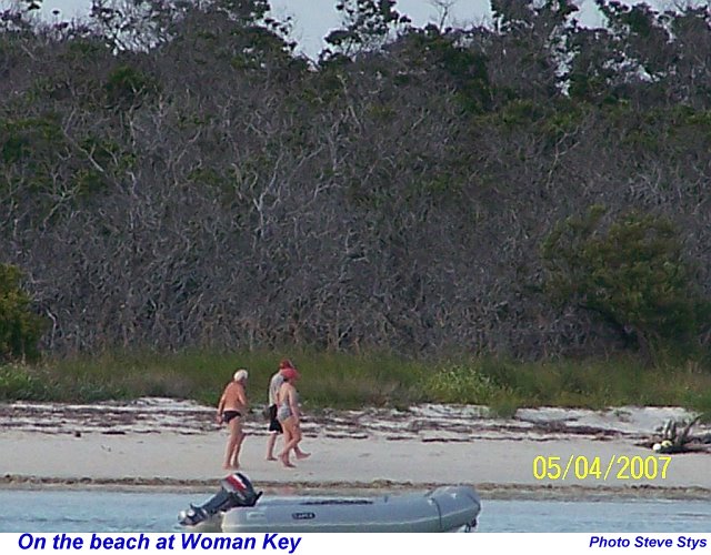
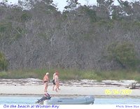
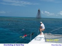 On Thursday the wind was still lighter and the sea calm, A perfect day for snorkeling at a reef. We reached Sand Key after just over 3 hours of motoring and tied up to one of the mooring buoys just west of the tower. The coral, while not as spectacular as in the Tobago Cays (see Grenadines essay), was interesting. We stayed 5 hours - snorkeling, swimming and relaxing. The we motored back to Woman Key and anchored in eight feet on a sandy bottom, half mile south of the west edge of the island.
This time we launched the dinghy and several of us went ashore to the sandy beach for an hour of exploring. picking up shells and looking at crabs. That night, about 2:30, a wind came up and it started raining. The hatches had to be closed. I stood in the rain and enjoyed a fresh water shower!
 Friday morning - our last day. A north-easterly wind was blowing with cloudy sky and showers. At 10:55 we pulled up anchor and sailed away for the last time. Close to Sand Key we had to head up to avoid shoals near Eastern Dry Rocks and had to start the engine again. In the meantime the sky had cleared and once more we enjoyed sunshine. After passing the Key West ship channel at 24º 28.8'N, we changed course to head towards Stock Island, directly into the wind. At 14:20 we dropped sails for the last time, stopped the engine and had a last swim and lunch just drifting. Then we docked at the marina at 16:10. We all enjoyed our first showers in a week!
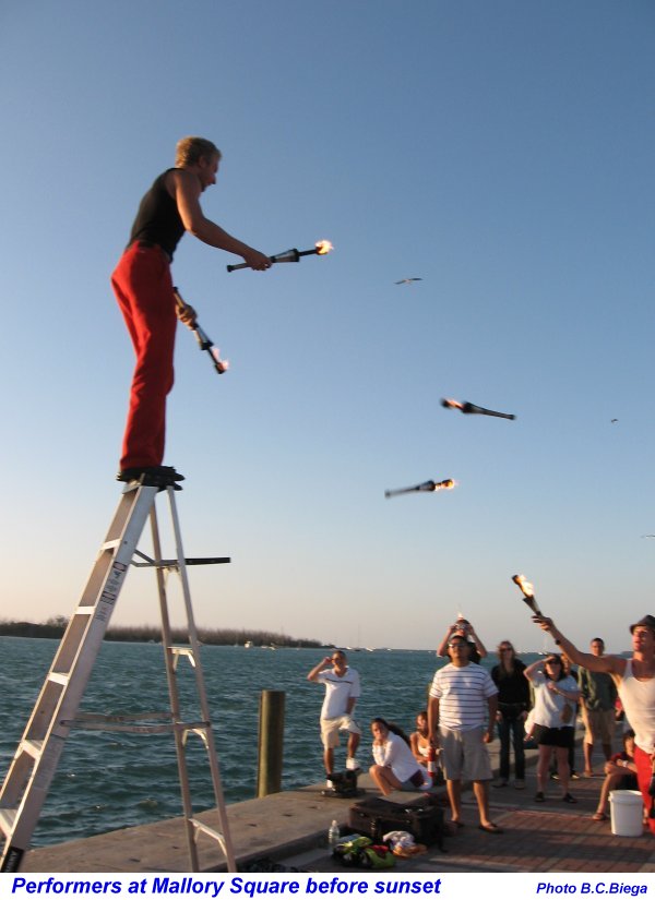
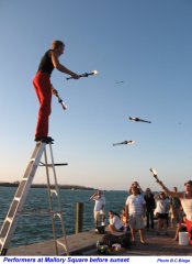
We rented a large car and drove into Key West to go to the sunset parade at Mallory Square, to watch the performers and then the sunset. After that dinner and the end of a perfect sailing vacation - perfect in spite of problems!
To see family photos taken on this cruise, click here!
NOTES
1. 1 nautical mile = 1 minute (1/60 of degree) of latitude (on vertical scale of chart). 1 NM = 1.15 Statute miles = 1853 meters.
Measure of speed or wind velocity: 1 Knot = 1 NM per hour = 0.514 m/s.
Measure of depth: 1 fathom = 6 feet = 1.83 meters
2. Useage of water. As a rule of thumb, the absolute minimum requirement is 1 U.S. gallon (3.8 liters) per person per day. This requires all washing as well as cooking of vegetables and pasta to be done with sea water. Normally, on cruising boats a spigot is provided to supply pressurized sea water at the galley (kitchen) sink. On this boat the connection had been disconnected!
In charter cruising about 20 gallons (80 liters) per person per week should be provided. This allows only one very controlled short shower of less than 10 seconds per person per day.

 This boat had a GPS connected to a computer with a 15" screen on which detailed charts are shown with the track of the boat traced on them as we sailed. Just as we were pulling away from Key West harbor under sail, the GPS transponder went out and we lost all position information. All attempts during the next hour to correct the situation were unsuccessful. I quickly plotted courses on the paper charts while we were sailing in approximately the correct direction. I was completely unaware of the fact that the instruments showing distance traveled and speed were in error by over 30%! They were reading low, so that when the instrument showed we had sailed 5 miles at a disappointing 5 mph, we had actually gone close to 7 miles. Nevertheless, by visual observations and taking bearings on visible objects, such as buoys and islands, I was able to navigate around an extensive shoal that was not on the charts (but about which we had been warned during the briefing) and we pulled into a pleasant anchorage to the west of the westernmost low-lying island of the Marquesas Keys, about half-way between Key West and our final destination - the Dry Tortugas.