
From Chicago to Florida - September, October 2001 - Part 2
Sailing
Adventures
|
THE VOYAGE OF "FAZISI" From Chicago to Florida - September, October 2001 - Part 2 |
Bill Biega's Sailing Adventures |
Selected extracts from the Log-book, enhanced with background information,
provide insight into details of navigation, problems and solutions.
Toronto to Halifax - down the St.Lawrence River.
Surfing the Atlantic - Halifax to Ft. Lauderdale.
See map of route.
Definitions and abbreviations.
| Date | Location | Nautical Miles |
| Sep 8 | depart Chicago | 0 |
| Sep 10 | Port Huron | 460 |
| Sep 11 | enter Lake Erie, Day of Infamy, borders closed | 70 |
| Sep 14 | borders reopen, enter Welland Canal | 190 |
| Sep 15 | arrive Toronto | 52, Subtotal 772 |
| Sep 17 | depart Toronto | |
| Sep 19 | arrive Montreal | 312 |
| Sep 21 | leave Montreal | |
| Sep 25 | Canso Strait, Port Hawkesbury | 667 |
| Sep 26 | arrive Halifax | 175, Subtotal 1154 |
| Sep 28 | depart Halifax | |
| Sep 30 | arrive Fairhaven/New Bedford | 410, Subtotal 410 |
| Oct 3 | depart Fairhaven | |
| Oct 10 | SW Point, Abacos | 1025 |
| Oct 11 | arrive Ft. Lauderdale | 170, Subtotal 1195 |
| Total rhumb line distance Note: actual distance sailed may be greater by approx. 10% | 3531 |
Click on any picture with color border to see it full size. Then click on the browser's "Back" button to return to this page.
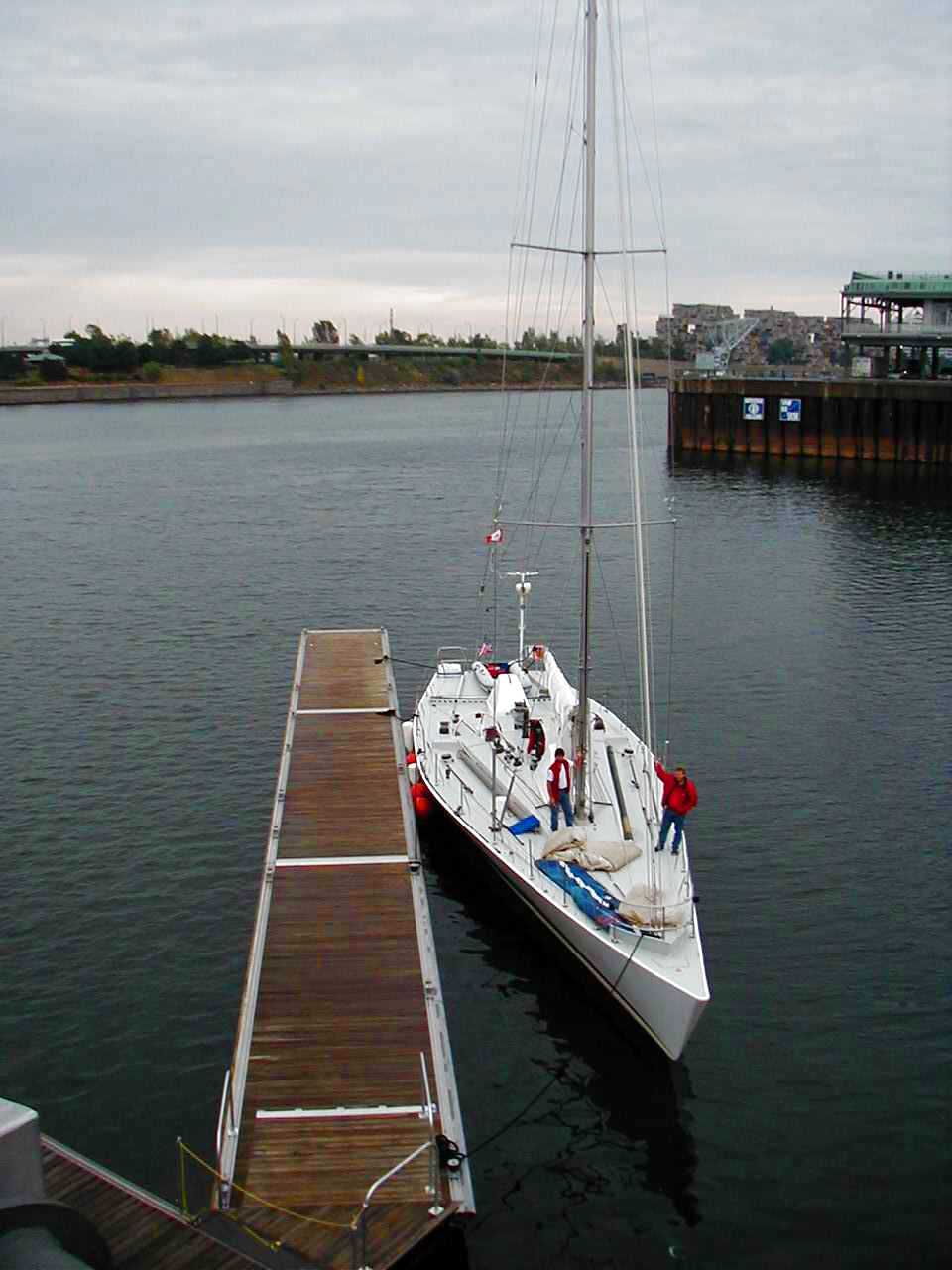
Saturday, September 15. "Fazisi" docked at Pier 4 in the downtown area of Toronto on Saturday morning. All Saturday and Sunday crowds of onlookers gathered on the dock. Members of the Polish Sailing Club and representatives of the local media were welcomed on board. One of the original technicians involved in the building of "Fazisi", now resident in Toronto, was very excited to see his creation. A Russian company. operating Russian-built hydrofoils on Lake Ontario, gave us free diesel fuel from their dock.
As a result of the September 11 disaster, additional crew from Chicago were unable to arrive. The crew for the next leg to Montreal consisted of the two partners Mark Witkowski and Bogdan Stojkowski, Jarek Lomnicki from Chicago, and Bill Biega who had come by Greyhound Bus from New Jersey to Toronto to serve as Navigator for the trip.
Monday, September 17. We left the dock at 5:43. 50 minutes later we were on course, under a clear blue sky with no wind and a calm sea. With the engine running at 2,300 r.p.m. we cruised along at an average speed of 7.5 knots on a course of 97° magnetic. The automatic pilot steered flawlessly in these conditions and the crew was able to relax and enjoy the warm sun. Running under engine we acted like a power boat, aiming for waypoints that had previously been set on the GPS. We passed Main Duck island shortly after sunset.
Tuesday, Sep 18. At 00:20 we passed our last waypoint on Lake Ontario, the RW Buoy flashing the letter A in morse code (44° 06.6'N 076° 24.7'W) and entered the St. Lawrence River. From here to Quebec, navigation was visual following the channel well marked with buoys and ranges. Unfortunately, we passed a very scenic part of the route, the narrow passage through the Thousand Islands, in the middle of the night. At 7:55 we passed under the Ogdenburg International Bridge, and at 08:55 arrived at Iroquois Lock, the first of seven locks of the St. Lawrence Seaway.
Two of the locks are American operated - Eisenhower and Snell, both 45ft. drops. The remainder are Canadian operated. At all of them pleasure craft are required to tie up at a small dock at the side and then call the lock-keeper by telephone. This results in additional delays, beyond waiting for commercial traffic (which has priority) to clear. In the case of the length and draft of "Fazisi" this requirement caused difficulties because the docks are designed for small craft and there was not enough room at several of them. On the average these delays amounted to an hour at each lock, the shortest being half-an-hour, the longest over two hours. The charge for pleasure craft under 100tons is Can$20 at the Canadian locks (although if US$20 was paid, no change was given) and US$20 or Can$30 at the US locks. See Seaway information.
After leaving the Snell Lock (not far from Cornwall, Ont), the river widens into Lake St. Lawrence and then Lake St. Louis. Much of these lakes is shallow and we kept to the dredged ship channel. Many ranges help to keep in the channel, often the current has a tendency to push the ship sideways into the shallower water.
I used these ranges to check the compasses.
At 20:30 we arrived at the first of the two Beauharnais locks. We had to wait over an hour for clearance. A much smaller, local sailboat was also waiting. The skipper of this boat was curious about "Fazisi". When he learned that we were on our way to Florida he indicated an interest in coming along as crew. He also gave us good information on a place to dock in Montreal. Then tired of waiting, he left and returned upstream to look for an overnight anchorage. When we were finally cleared to enter the lock, the lock-keeper was concerned about his departure and sent a car to look for him! We were able to clear through the second Beauharnais lock without further delay, but it was close to 23:00 when we finally locked through and entered Lac St. Louis. We decided to anchor overnight, so that we could arrive in Montreal during daylight hours. In darkness; we dropped the anchor at 23:30. After setting an anchor alarm on the GPS and taking bearings on three visible lights, we all had a good night's sleep.
Wednesday. Sep 19. At 8:00 we pulled up the anchor and stowed it away below. It took an hour to cross Lac St. Louis and enter the 14 mile long South Coast Canal which skirts the rapids of the St. Lawrence River. We passed through the last two locks in the southern outskirts of Montreal, St. Lambert and Ste. Catherine, without further delays, and at 12:55 we rounded the buoy marking the end of the Seaway. Half an hour of motoring upriver, against a 3 knot current brought us to the marina at Quai Jacques Cartier, a few minutes walk from the heart of
Old Montreal. We were happy to enjoy comfortable showers, with plenty of hot water.
Later that afternoon, Mark Los arrived by car from Chicago, bringing with him fresh provisions and the genoa sail, that had been repaired at a sail loft near Toronto. Mark Witkowski and Jarek returned the following day to Chicago, driving the same car.
 Thursday, Sep 20. A gray, cloudy day with rain showers. The day was spent cleaning up below decks, securing all gear for expected rough seas. Fuel tanks were filled from jerry cans that had been carried from Chicago, as the fuel truck could not make delivery until late Friday. The special modem for the SSB radio email system was delivered and installed. Marc Bourdon, the Montreal sailor whom we had met at the Beauharnais Lock, came aboard. We all enjoyed eating ashore, and fresh baguettes for breakfast. Bill obtained weather forecasts from the internet at an internet café. which indicated light winds in the Bay of St. Lawrence, hurricane Humberto will pass well SE of Halifax.
Friday. Sep 21 09:55 we left the marina, motoring downstream with an aiding current, weather partially sunny, light wind <7knots.
Crew: Bogdan, Bill, Mark Los, Marc Bourdon.
14:00 passing Sorel. River widens into Lac St.Pierre. We raise genoa fore-sail. After one hour drop it as wind too light.
21:30 intricate set of course changes, approaching Donnacona, still using visual navigation along buoyed ship channel. 3-hour watches in pairs.
Saturday, Sep 22. Passed Quebec shortly after 2:00.
04:20 passed by freighter going downstream and cruise ship going upstream.
05:20 cruise ship "Royal Empress" passes going upstream.
05:50 channel now much wider, resume motoring from waypoint to waypoint.
09:00, approaching Ile aux Coudres in poor visibility, which quickly changes to dense fog.
10:35, ship passes ¼ mile to starboard - Heard fog-horn, no visual contact.
11:36, reach waypoint at 47° 30'N 070° 08'W. Change course to 50°T=69°. From here planned course is south and east of boundary of designated shipping channels. We are now under influence of tides, sometimes light current is aiding, sometimes unfavorable.
All day and next night fog, often very dense. Navigated strictly by GPS from waypoint to waypoint,
Occasional radar targets, none closer than 1 mile, probably fishing boats.
Sunday, Sep 23. Fog finally cleared after 9:00. Sunny, light haze.
14:45. 49° 18.9'N 065° 26.8'W. Furthest north point. Wind 280° WNW 28K. Waves 4ft. small white caps. Stop engine. raise jib. Sailing at 7.4K.
17:30. 3.5NM from coast, west of Cap Madelene, wind dropping, speed 6K.
21:30. Wind has dropped to <10K. Drop jib. Start engine, 2100rpm.
22:35. Aurora borealis (northern lights) in northern sky - phosphorescence in wake and waves.
 Monday, Sep 24.
06:01. 48° 36.8'N 063° 48.6'W. East of Cape Gaspé, course 170°, clear sky, calm. Orca whales sighted. Apparent magnetic disturbance, magnetic compass reads 12° less than GPS bearing. Note on chart indicates that magnetic disturbances are to be expected in this area.
Maintained all day, towards next waypoint, east of Prince Edward I. Sea remained calm, light wind. Fog noted in evening entries.
Monday, Sep 24.
06:01. 48° 36.8'N 063° 48.6'W. East of Cape Gaspé, course 170°, clear sky, calm. Orca whales sighted. Apparent magnetic disturbance, magnetic compass reads 12° less than GPS bearing. Note on chart indicates that magnetic disturbances are to be expected in this area.
Maintained all day, towards next waypoint, east of Prince Edward I. Sea remained calm, light wind. Fog noted in evening entries.
Tuesday, Sep 25. 01:45. Radar contact on relative bearing 050°, distance 10NM. This is East Cape of Prince Edward Island. Fog.
10:30. Close to waypoint 45° 41.5'N 061° 28'W, entering Canso Strait. Visual navigation.
11:15 entered Canso Lock after tug towing barge departed. The dam and this lock were built in 1959 to stop very strong tidal currents. Change in water level at this time only 2 feet.
Could not start engine to leave lock, swing bridge already opened. Transmission had jammed when engine had been stopped. This problem was to plague us for rest of voyage. Required forcing transmission into neutral and into gear at engine, down below.
13:10 local Atlantic D.S.T. docked at government pier in
Port Hawkesbury. Attempts to raise Yacht Club on radio had been unsuccessful, Yacht Club closed.
Many local residents came to look at "Fazisi", and were helpful in arranging for a fuel truck to deliver 300 liters of diesel fuel. A foreman from the Stora Enso Paper Mill, who was on his day off, took Bill and Mark to the Marine supply store and to the supermarket in his car. Both were extremely well stocked considering that Port Hawkesbury has only 4,000 inhabitants. But it is the principal town in the south portion of Cape Breton Island.
15:45. Left Part Hawkesbury dock. Visual navigation through Canso Strait. Then from waypoint to waypoint. Sea calm, water temp. 61°F. Partly cloudy, light wind from SE.
20:50. 45° 14'N 060° 50'W. SE of Cape Canso. Our most easterly position. Change course to 260°M, 120NM to Halifax. Wind 7K SE, swells about 3 feet.
Wednesday, Sep 26. Cruising along coast of Nova Scotia, about 10NM from land, foggy.
12:00, Dense fog. Radar target at -10°, ½ mile.
12:05. passed target ¼ mile to starboard, no visual contact.
12:45. Whistle buoy H4 (entrance channel to Halifax harbor), abeam to starboard.
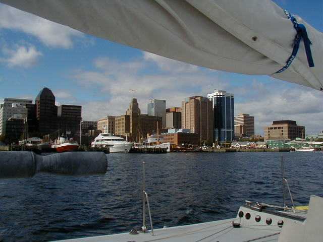
Halifax Harbor Traffic Control guides us into harbor in dense fog. Bill sits at radar with chart and in radio contact on Channel 14, relaying instructions to Bogdan at helm. Pass several ships, barely visible. Visibility improves to about ½ mile in final approach to docks and Georges Island.
13:45, dock at Queen's Wharf, a couple minutes walk from downtown
Halifax and from Murphy's Restaurant.
Bogdan checked into the Sheraton hotel so that we could all enjoy hot showers and do laundry, as there were no facilities at the dock. After getting cleaned up we all enjoyed a good dinner ashore.
Halifax is a charming town, with many old buildings in the harbor area and a great selection of restaurants. The one we enjoyed most was "Salty's" right on the waterfront.
Thursday, Sep 27. A warm, sunny day. Crowds came to the dock to look at "Fazisi." We contacted the manufacturer of the modem and software that were supposed to enable us to receive and send emails from the SSB radio. We had been unable to get the system to work during the voyage from Montreal. After going through a lengthy check out procedure relayed by phone, with attempts at transmitting and receiving, the Manufacturers Service department concluded that the problem lay in the SSB radio installation, most likely improper grounding. However no service personnel was available in Halifax to assist us. We also had software which was supposed to enable us to download weather maps into the laptop computer. We could not make this work either, probably for the same reason. Therefore I went to an internet café in town and downloaded all weather maps and text forecasts from the NOAA website. These indicated a clear window of opportunity with fair weather, at least through Sunday, for all the areas south of Halifax and over the Gulf Stream.
Additional crew had been arranged by Mark Witkowski. They arrived from St. Petersburg, FL.
that evening. To our amazement two of the three new crew were women!
Friday, Sep 28. The port of New York was still closed to all traffic. Therefore we decided to sail straight from Halifax to Florida, by the fastest route, to take advantage of the fair weather window. This route would take us south of the Georges Bank, across the Gulf Stream at about 38°, the latitude of Norfolk, VA., then around Abaco I. in the Bahamas and straight to Miami. After topping up with diesel fuel and fresh water, we departed the dock at 11:25.
Crew: Bogdan, Bill, Mark, Marc and the new arrivals - Ken Davis, Georgiana Hart, Casey (Catherine) Considine.
Once more the wind was very light. After leaving Halifax harbor, we raised the genoa sail, but were forced to take it down and continue under engine.
15:30. At 44° 13'N 063° 42'W. Clear blue sky, wind speed 6K from NE. Sea relatively calm with 3 foot swells. Changed course to 239° towards the next waypoint south of Georges Bank, 235NM away. Engine speed 2,200rpm, speed 7.2K through water.
19:00 received disquieting weather report from NOAA. Low pressure moving rapidly from mainland will cause gale force winds south of Georges Bank on Saturday, with 20 to 30 foot waves in Gulf Stream. Canadian weather forecast still good for area north of Georges Bank.
19:55 change course to 250° to stay north of Georges Bank. Established new waypoints to go around projected storm path, expect to be able to turn south behind the low pressure cell, east of Nantucket Shoal.
With seven person crew, we stand 4 hour watches in pairs. The cook, Mark. is not required to stand watches. He will be on call when required to handle sails.
Saturday, 29 Sep. 03:00 Wind 12K. raise genoa, motor sailing.
07:30. 43° 00'N 065° 40.5'W. Wind speed 12-15K from N. Raise main sail. Shut down engine. Course 270°M. Speed 8K.
11:00. 42° 54.5'N 066° 26'W. Wind veering to NE, 16-20K. Clear sky to N and W, Clouds S and E. Desirable course 252°M but can only hold 270°
14:00. Wind increasing to 25K. Decide to change genoa to smaller jib and put reef in main sail. Dropped genoa, however unable to lower main, it is jammed.
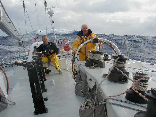
With engine on, Bill at helm, crew fights for 2 hours to get Main down, unsuccessfully. Finally it is determined with binoculars that safety line has jammed in sail track near top of mast. Wind continues to increase and seas to build up.
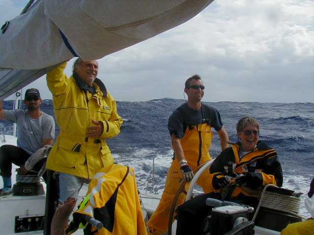 19:15. Finally got main sail down and #1 jib up, just after sunset. Engine off. Clear sky. Wind 30 - 35K, seas 6-8ft. The pin at gooseneck, that holds boom to mast has broken. Boom secured to mast with line. We set 2 hour watches in pairs.
21:30. 42° 13'N 067° 47'W. Wind 30 - 35K from NE, seas 8-12ft. New weather forecast indicates that low pressure has stalled and gale force winds will continue. Decide to head to Newport to Fairhaven shipyard (where "Fazisi" lay for several years) for repairs. Establish new plan to go to Cape Cod Bay, then through Canal and Buzzards Bay to seek lower seas. Change course to 280°, distance to Cape Cod Bay 104NM. speed 9-10K.
Sunday, 30 Sep. 04:30 42° 28.8'N 069° 17'W. Wind 35K with occasional gusts to 42K, seas 15ft. from behind.
07:10 sighted land. 42° 07.2'N 069° 53.6'W. Wind has diminished to 20-30K.
08:30 Cape Cod lighthouse abeam, about 3 miles away. Note: we have no detail chart for Cape Cod Bay and Canal. Bill establishes waypoints from data in Reed's Almanac, as we have no detail chart for the area.
12:10. Entered Cape Cod Canal. Shortly after the maximum of the ebbing current, which is in our favor, running east to west at 4K.
13:05 Exit Canal into Buzzards Bay. Bill has 20 year old chart for area. Set waypoints for passage to Newport. Cannot find Fairhaven anywhere in vicinity of Newport.
14:30. Bogdan learns by cellphone that Fairhaven is near New Bedford, not Newport, just as we are approaching entrance buoy to 8 mile long channel to New Bedford and Fairhaven.
16:05. Tie up to dock at Fairhaven Shipyard, after a very wet drive to windward up the channel. The shipyard staff greeted "Fazisi" enthusiastically.
We all checked into the Holiday Inn for the duration of the stay in Fairhaven.
Georgiana and Ken returned to St.Petersburg. Casey is enthusiastic and will stay, but we will still be short of crew. Marc calls friends in Montreal. Bogdan's wife arrived from Chicago, she drove from Providence, RI, airport so we have transportation.
Monday and Tuesday, 1-2 October
Fairhaven, MA. It is a small, pretty town with several marinas and shipyards and home to a large fishing fleet. It is connected to its larger neighbor, New Bedford by bridge. A machine shop manufactures a new pin for the gooseneck. Attempts to get repairs for the transmission and the SSB radio are unsuccessful. We clean up above and below deck. Purchase fresh supplies and a barometer and clock for the navstation. The water tanks are cleaned out. We enjoy warm weather.
On Tuesday, at the library, I get weather maps and text reports from the NOAA website. They indicate good weather through the Gulf Stream through Thursday, with a new low pressure system moving from the mainland on Friday. Tuesday evening one of Marc's contacts, Sylvain Gougeon, arrives from Montreal by bus. He is a policeman with sailing experience in regattas in Montreal and France.
 Wednesday, 3 Oct.. After completing repair, topping up fuel and water tanks, we leave the dock at 14:00. We reach Buzzards Bay Tower at 16:50. Wind 20K, sea 3-4ft. Raise #1 jib, shut down engine. Best course we can hold is 170° on starboard tack, speed 6.5K.
We establish 4 hour watches. That night we Enjoy a full moon.
12:00. 39° 32.3'N 070° 16.3'W. Wind SW 22K - 25K, seas 5 - 8 ft. Distance sailed since 14:00 yesterday - 155NM. Baro 1022mB. Sylvain succumbed to motion sickness in spite of patch.
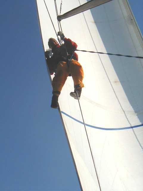
15:00. A small tear appeared in luff of sail at height of second spreader. Bogdan hoisted up and succeeded in repairing with sail tape. No change in conditions but VMG increased to 8.5K, apparently aiding current. Water temp. 68°F.
Friday, 5 Oct. 00:00. 37° 58.4'N 069° 50.4'W. Course 185° wind 20K, speed 7.7K, sea 6-8ft. baro 1023mB. water temp. 77°F - definitely in Gulf Stream.
12:00. 36° 48'N 069° 22'W. No change in wind and sea. Sky clear. Last 24 hour distance 156NM.
During last 3 hours, laboriously raised main to second reef point and securely tied reef lines through all cringles. This increased speed only ½ knot, but the is boat better balanced, almost steers herself.
Saturday, 6 Oct.
12:00. 34° 18.8'N 069° 02.0'W. Wind 22K, speed 9K. course 255°M, sea 6 - 8ft. baro 1019mB. Distance and course made good last 24hrs: 145NM 174°T (This is in a straight line, distance actually traveled is greater.) Weather forecast from NOAA - strong cold front along line SW to NE behind us. Gale warnings for entire area north of front, seas in Gulf Stream off Cape Fear and Cape Hatteras up to 20ft. Front expected to slide eastwards toward Bermuda by Monday. Easterly winds 20K south of 30°N. We got through just in time!
18:00. Course 235° Wind 22K, quartering seas 6-8ft make steering difficult. Baro dropping - 1016mB. Motor sailing
Sunday, 7 Oct. 00:00 Occasional thunderstorms and heavy gusts. Cold front is catching up with us.
12:00. 33° 08.5'N 070° 40.8'W. NW Wind 15K, speed 6K. course 235°M, sea 3ft. baro 1016mB , holding steady. Distance and course made good last 24hrs: 125NM 230°T. Last few hours wind has been variable. Showers.
14:30. Wind increasing to 20 -25K from NW. Raise jib#1, stop engine. Course 235°M, speed 8K.
 Monday, 8 Oct.
12:00. 31° 06.0'N 073° 30.9'W. Wind NE 20K, speed 6.5K. course 240°M, sea 6 - 8ft. baro 1026mB. Distance and course made good last 24hrs: 175NM 225°T. Difficult to hold course, change to port tack to course of 215°M. Weather forecast indicates that cold front is pushing further southward. Gale warning for coasts of Carolinas.
Monday, 8 Oct.
12:00. 31° 06.0'N 073° 30.9'W. Wind NE 20K, speed 6.5K. course 240°M, sea 6 - 8ft. baro 1026mB. Distance and course made good last 24hrs: 175NM 225°T. Difficult to hold course, change to port tack to course of 215°M. Weather forecast indicates that cold front is pushing further southward. Gale warning for coasts of Carolinas.
Marc stopped up drains in starboard cockpit, filled with water and had bath.
20:30. Close encounter with east-bound freighter. Made radio contact on Ch.16. Agreed to course change, we changed to 180°, freighter changed to 195°. Freighter passed in front of us about ½ mile, then we resumed normal course. (Bill & Sylvain on watch)
22:00 wind increased to 27K from NE, seas 10-15ft. Speed 10K.
Tuesday, 9 Oct. 12:00. 28° 15.5'N 075° 15.2'W. Wind 35K, speed 10.2K. course 225°M, sea 10-15ft. baro 1014mB, cloudy - occasional sun. Distance and course made good last 24hrs: 200NM 238°T. At times we are surfing on waves at speeds of 14K, highest recorded 17K! This just with small jib.
 Wednesday, 10 Oct. 03:00. 26° 25.8'N 076° 39.6'W. Wind NNE 30K, speed 8K. course 215°M, sea 10ft. baro 1020mB. 1.5NM east of Elbow Cay waypoint, just changed course to Abaco SW Point waypoint.
08:00. 2NM SE of Abaco SW Point waypoint. Can see huge fountains of waves on Hole in the Wall rock. Change course to 295° towards next waypoint, which is north of Great Isaac Light, distance 120NM.
09:45. We have been advised that we should proceed to Fort Lauderdale, there is no dock space available in Miami. To avoid arriving at Fort Lauderdale in the middle of the night, we decided to head towards Freeport on Grand Bahama Island and there hold position until late evening. Change course to 315°
12:45,. 26° 12.00'N 077° 52.8'W. Wind ENE 30K, speed 10K. course 320°M, sea 3-4ft. baro 1020mB. Distance and course made good last 24hrs: 237NM, best yet! We are now in wind shadow of Abaco Island, waves are much lower, although wind speed hasn't changed appreciably.
16:15. Land about 3 NM distant, 26NM east of Freeport. Drop sail.
We experiment with heaving to, to determine how "Fazisi" would behave in bad storm conditions. We found thet she tends to lie sideways to the waves, which is undesirable. The we turned downwind. In 4ft waves and 20K wind, the autopilot holds "Fazisi" easily in position, going about 4 knots without any sails or engine. It appears that in extreme storm it would be best to turn "Fazisi" downwind and trail loops of lines and other objects to slow her down. She was originally designed to go downwind in the Roaring Forties of the Southern Ocean.
18:00. Lights of Freeport and associated resorts abeam, 2 miles off.
21:30. 25° 27.4'N 078° 44.4'W. Wind E 25K, course 260° speed 5K. Running engine to charge batteries and proceeding to Fort Lauderdale. Most recent weather forecast, by phone from Florida, indicates cold front has reached Dry Tortugas. In Gulf Stream off Florida coast, winds ENE 20K, seas 8ft.
22:30. Raised jib, stop engine.
Thursday, Oct 11. 06:00 We are in center of strongest current as indicated by the following: Course 250°, Course over ground 290°(correct course to Ft.L), speed 7.8K, wind E 23K, sea 6-8ft. Lights of Hollywood and Ft. Lauderdale visible.
08:00. 1.0NM south of Buoy "PE" - entrance to Port Everglades (Ft. Lauderdale)
08:21. Arrive at entrance to Port Everglades and manoeuver under engine to take down sail.
08:50. Motoring in large following sea through entrance channel. In contact with Yacht Harbor at Westin Hotel (just south of bridge). Dock space available to us for only two days. Asked to wait half hour until dock personnel arrives.
Tight security in harbor. We had planned to wait in turning basin, but Coast Guard and County Marine police do not permit this. At slow speed proceed though Waterway channel towards marina.
09:20. Tie up at dock, next to mega yachts from various countries. Proceed to unload and clean up. Staying in hotel until flights out are arranged. The voyage is over.
14:20. Mark Witkowski arrives from St. Petersburg with three other crew to take "Fazisi" to St. Petersburg via Key West. Marc and Casey decide to stay on board.
# # #
Return to top of this page.
Return to Sailing Table of Contents
Return to Home Page
Copyright © 2001 B. C. Biega. All rights reserved.